

12 Must-See Spots in Death Valley National Park
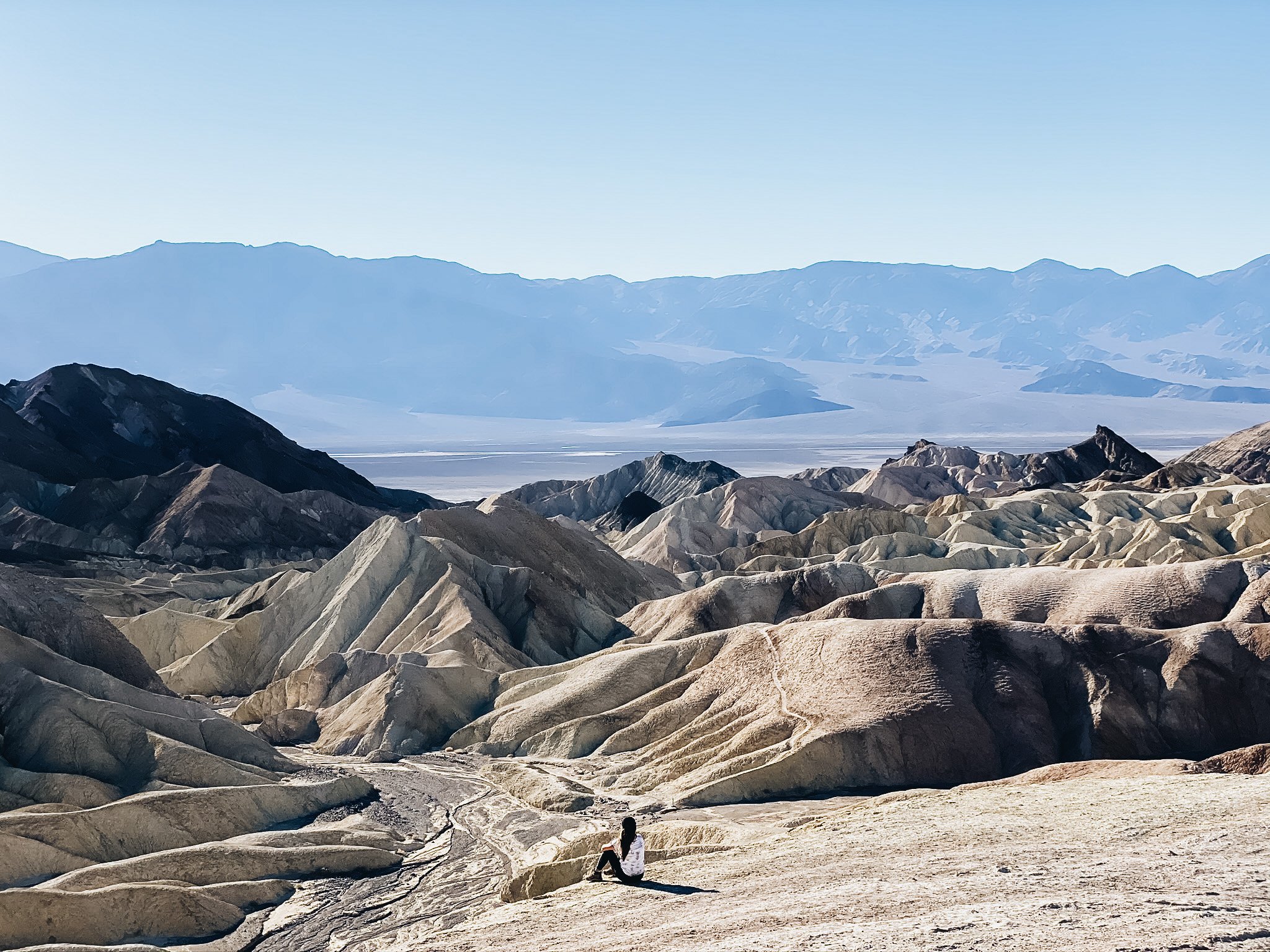
Zabriskie Point is my favorite part of Death Valley National Park
UPDATED POST: May 10, 2022
If you are like me, you probably thought that deserts are boring, open spaces. I could not have been more wrong. Death Valley National Park might just surprise you. This land of extremes is the largest US national park and the hottest, driest and lowest park as well. And yet, in stark contrast, it is home to many species of plants and animals that have adapted to this harsh desert environment. UNESCO included Death Valley as the principal feature of its Mojave and Colorado Deserts Biosphere Reserve in 1984. Still think the desert is boring? These 12 places to see in Death Valley National park will definitely change your mind.
KNOW BEFORE YOU GO
The best time to go to Death Valley National Park is from November to May. It is not advisable to go in the summer due to scorching temperatures.
Plan ahead. Like most national parks, cellphone coverage is spotty here so prepare your maps, itinerary, first aid kit, emergency kit and lots of water.
Because of the rough and uneven terrain, a lot of emergencies in the area involves flat tires. Make sure you or your companions know how to change a flat tire. This road is also infrequently patrolled so if you get stuck here, you’re kind of on your own eek.
There are many restrictions on bringing pets to the park (does not apply to service animals). You may take them on roads and developed areas such as campgrounds and picnic areas but they should be leashed. Pets are not allowed inside buildings and most trails. Do not leave your pets in the vehicle.
The sun is intense (even when we went in the fall) so slap on that sunscreen.
As always, follow the Leave No Trace principles.
MUST-SEE PLACES IN DEATH VALLEY NATIONAL PARK
1. ZABRISKIE POINT
Location: On CA-190 east of the official Death Valley visitor center, the Furnace Creek Visitor Center
Distance: 0.3 miles, out and back
Difficulty: Easy. From the parking lot, the point is a quarter of a mile walk up a small hill on a paved trail.
Allot: 30 minutes-1 hour
Bathrooms: Accessible vault toilets
Pet rating: Not friendly. Pets not permitted here.
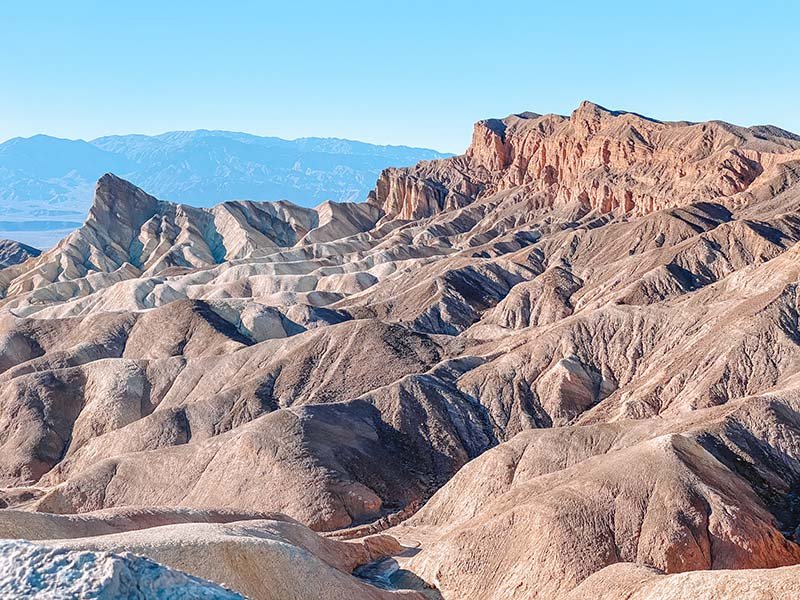
Named after an American businessman who devoted many years of dedicated service to Pacific Coast Borax Company, Christian Zabriskie, Zabriskie point is the most photographed area of Death Valley National Park. It is not surprising given the spectacular views it affords of the badlands below. The powerful force of water carved these magnificent yellow and brown striped hills into existence. Jutting out to an elevation of 823 feet, Manly Beacon is the most pronounced feature seen in Zabriskie Point. In the distance, the vast salt flats are visible against the backdrop of the Panamint Mountains. This jaw dropping vista is a popular spot for viewing both sunrise and sunset.
Trip Trivia
If you are a Star Wars geek like my husband, you might like this cool tidbit. Shots taken from Manly Beacon and Red Cathedral, another striking landform seen from Zabriskie Point, were used as basis for digitally altered shots to form the planet of Arvala-7 in the first season of the Mandalorian.
You can stay here as little or as much as you like to admire the scenery or you could wander down into the variegated dunes. There are hiking trails such as the Badlands Loop and Gower Gulch Loop which give you a more in-depth look at these striking landforms.
2. BADLANDS LOOP
Location: Zabriskie Point on CA-190 located 3.5 miles east of Badwater Rd
Distance: 2.7 mile loop
Difficulty: Moderate
Allot: 1.5-2 hours
Bathrooms: Accessible vault toilets in Zabriskie Point
Pet rating: Not friendly. Pets not permitted here.

This trail starts from the base of Zabriskie Point and loops through colorful badlands and arid terrain. It is easiest to follow by turning to the right. Some areas of the trail weave through some hillsides with steep drops so it could be unnerving for those who are afraid of heights. Borax, the “White Gold of the Desert”, was mined extensively in this region in the 1880s and in one section of the trail, several mine shafts remain. Exploring these mine shafts is not recommended as they are unstable and dangerous.
The Badlands Loop meets up with the Gower Gulch Loop. There are trail markers and numerous signs to guide you the correct path.
3. GOWER GULCH, GOLDEN CANYON AND RED CATHEDRAL
Location: Start at the Golden Canyon trailhead located 2 miles south of CA-190 on Badwater Rd. If you did not start from the Badlands Loop.
Distance: 5.3 mile total = 4.3 mile Gower Gulch loop. Add an extra mile for the spur trail to Red Cathedral.
Difficulty: Moderate
Allot: 2.5-3 hours
Bathrooms: Accessible vault toilet in Golden Canyon parking lot.
Pet rating: Not friendly. Pets not permitted here.

Image courtesy of NPS
A weaving landscape of golden hills and narrow canyons, this trail has it all from easy flat walks to some minor rock scrambling to more strenuous explorations. This can be combined with Badlands Loop or hiked from Zabriskie Point but the entire loop would be strenuous.


Topographic map and route description of Golden Canyon area courtesy of NPS
4. DARWIN FALLS
Location: Old Toll Road, approximately 59 miles west of Furnace Creek Visitor Center via CA-190 W
Distance: 2 miles, out and back
Difficulty: Moderate
Allot: 1.5 - 2 hours
Bathrooms: None. Closest restrooms are located at the privately owned Panamint Springs Resort.
Pet rating: Not friendly. Pets not permitted on this trail.
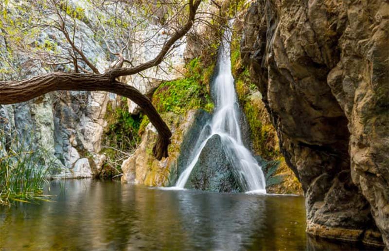
Yup, you read that right. There is a (year-round!) waterfall in Death Valley National Park. This desert oasis is nestled in a narrow canyon in the western edge of the park. The spring-fed water creates a unique habitat for the wildlife and vegetation in this area. Swimming is not allowed in this pool as it is the drinking source for nearby Paramint Springs Resort.
You will cross a stream so waterproof boots might be a good idea. Unlike most parts of Death Valley, this trail offers ample shade and much-cooler canyon air. The trail ends at the pool where the 20-foot waterfall with its two channels flow into. Consider bringing lunch as this is a peaceful and quiet place for a picnic. If you are feeling more adventurous, climb up the hillside on the left of the canyon where you will be treated to a view of a three-tiered 140-foot waterfall above the lower falls.
5. WILDROSE CHARCOAL KILNS
Location: Along Emigrant Canyon Rd. via CA-190 W, approximately 62 miles southwest of Furnace Creek Visitor Center
Distance: Can be viewed directly from parking lot
Difficulty: Easy
Allot: 30 minutes - 1 hour
Bathrooms: Vault toilet in parking lot.
Pet rating: Not friendly. Pets can stay in the parking lot while you view the kilns across the street.

Image courtesy of NPS
Built in 1877, the Wildrose Charcoal Kilns are one of the best preserved and largest examples of historic charcoal kilns in the West. These ten beehive shaped masonry structures were originally built to provide charcoal to smelters adjacent to lead and silver mines in the Panamint Valley. The kilns have been well preserved due to their short operational lifespan (said to be just two years), their remote location and preservation and restoration efforts.

The last two miles leading up to kilns is gravel and although, it is generally passable by most vehicles, a higher clearance vehicle is recommended and checking current conditions before travel is wise.
Travel Tip
Before you venture out into the desert, dress appropriately and wear layers as it could be cold in the morning and get very hot in the afternoon. Use reef-safe sunblock and wear a hat to protect yourself from the sun. Bring plenty of water and hydrate constantly during hikes.
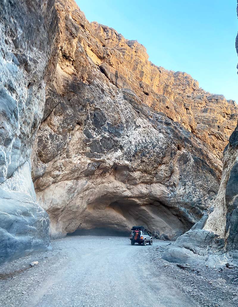
6. TITUS CANYON
Location: Entrance to Titus Canyon Rd is off of Nevada Highway 374 (also called Daylight Pass Rd)
Distance: 27 miles (driving)
Difficulty: Easy
Allot: 3 hours (more if you are hiking the narrows)
Bathrooms: None
Pet rating: Friendly. Because it is on a dirt road, pets are welcome. Because this is a bighorn sheep habitat, it might be best to keep your fur babies leashed to avoid endangering these animals.
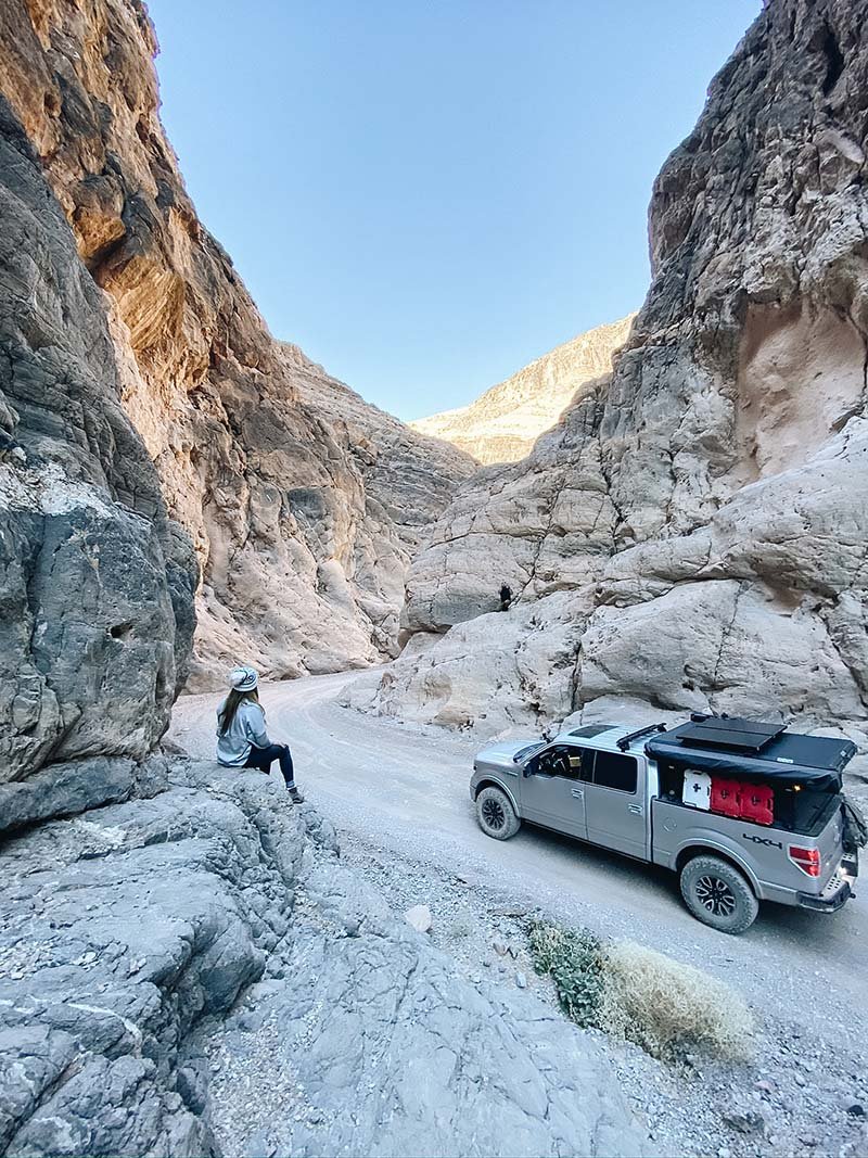
Titus Canyon Rd is the most popular back-country road in Death Valley National Park. Titus Canyon is a narrow chasm cut across the Grapevine Mountains of the Mojave Desert. It features limestone strata, petroglyphs, colorful rock formations, and some native plants. It is magnificent and will leave you feeling so tiny but truly in awe of nature.
This dirt road is entirely one way, save for the last 3 miles. Some hold-your-breath sections involve some steep twisting roads with tight turns so exercise caution when navigating the area. Because of the rugged terrain, a high clearance vehicle is highly recommended. Check road conditions here before you go as some sections of the road are steep and narrow and subject to closure after heavy rain due to flash flooding. If you would like to hike up the narrows, park here and hike as far up the canyon as you want. Make sure you are watching out for oncoming vehicles.
7. ARTISTS DRIVE AND ARTISTS PALETTE
Location: Artists Drive one-way scenic loop begins 8.5 miles south of CA-190/Badwater Rd junction. Vehicles over 25 feet long are prohibited due to sharp turns and large dips.
Distance: 9 miles
Difficulty: Easy
Allot: 30 minutes, more if you are exploring Artists Palette or plan to take a lot of photos (me🙋🏻♀️!)
Bathrooms: Vault toilet in parking lot.
Pet rating: Ok along Artists Drive

This popular scenic drive takes you through beautiful color-splashed hills along a winding desert road. These rainbow hills are formed from volcanic deposits rich in compounds such as iron oxides and chlorite, which create that stunning rainbow effect. There are no maintained trails along this loop but there are several pull outs you can park in to explore on foot.

Artists Palette lookout is about halfway through the drive, where you will find a small parking lot and a short trail leading up to the multicolored hills. Although it is spectacular any time of day, it is most dramatic in the afternoon light and during golden hour.

Trip Trivia
Another Star Wars fun fact: Parts of Star Wars Episode IV: A New Hope were filmed in Artists Palette
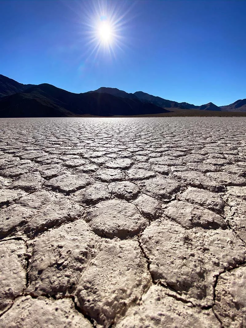
8. BADWATER BASIN
Location: Badwater Rd, 17 miles south of Furnace Creek Visitor Center
Distance: 1 mile to edge of salt flat
Difficulty: Easy
Allot: 30 minutes -1 hour
Bathrooms: Accessible vault toilet in parking lot
Pet rating: Not friendly. Pets not permitted on this paved trail.
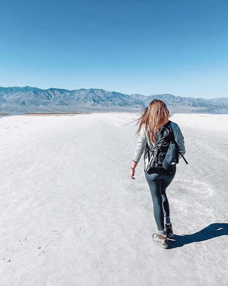
Badwater Basin is the lowest point in North America at 282 ft below sea level. Sodium chloride (table salt), calcite, gypsum and borax make up these vast salt flats. This was once the site of the large inland Lake Manly which evaporated tens of thousands of years ago. Because that ancient lake had no outlet, sediment and salt accumulated over time leading to the concentrated salt deposits left behind when the lake dried up. The repeating pattern of the polygonal forms is said to be caused when volume of the salt crust decreases, by either thermal contraction or desiccation (water removal).

The Badwater Basin name originated from stories about a mule of an early surveyor refusing to drink from the spring-fed pool near the present-day boardwalk. The undrinkable “bad water” is actually just very salty because of the high salt content. This pool is home to an endemic snail, the Badwater snail, found only at this location. The pool and boardwalk are easily accessible from the parking lot off Badwater Road. An easy 1.5-2 mile roundtrip walk out onto the salt flats gives you the best views of the salt polygons.

9. DANTE’S VIEW
Location: Dante’s View Rd, via CA-190, about 25 miles southeast of Furnace Creek Visitor Center
Distance: Less than a mile from parking lot.
Difficulty: Easy
Allot: 30 minutes - 1 hour
Bathrooms: Vault toilet in parking lot.
Pet rating: Not friendly
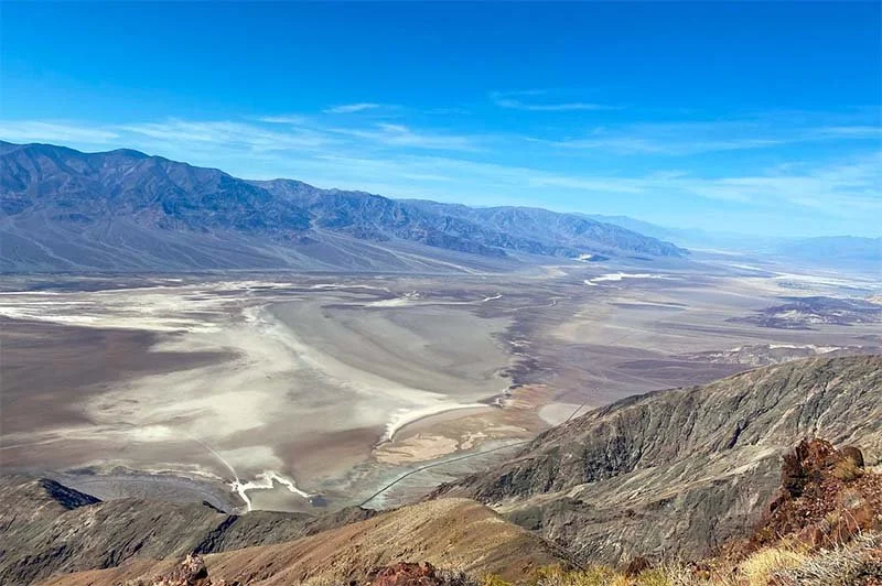
Dante’s View imparts visitors with 360 degree breathtaking views of the Southern Death Valley Basin. See the Owlshead Mountains to the south, the Funeral Mountains to the north and to the East, the Greenwater Range. To the West, across the Badwater Basin, the Panamint Range rises dramatically to Telescope Peak. Incredible during the day and even more magnficent at night, Dante’s View is especially popular for sunsets.
Travel Tip
Pack a windbreaker or a light jacket. The elevation and wind make Dante’s view a lot chillier than the valley below.
10. UBEHEBE CRATER
Location: Ubehebe Crater Rd., approximately 56 miles northwest of Furnace Creek Visitor Center.
Distance: The walk around the rim of Ubehebe Crater is about 1.5 mile round-trip.
Difficulty: Depends. Walking to the bottom of the main crater is easy. The walk back is another matter, however. The very loose gravel makes for an exhausting climb. Walking around the rim is moderately difficult.
Allot: 1 hour if doing the rim hike, more for hiking crater from the bottom up.
Bathrooms: None. Nearest restrooms are located at the unstaffed Grapevine Ranger Station 5 miles east of the crater.
Pet rating: Not friendly. Pets are not permitted around the rim but can stay in the parking lot where you can easily view the crater.

Ubehebe Crater is a large volcanic crater created through the power of maar (explosion pit) volcanoes. When molten lava came into contact with ground water, intense heat created steam which eventually produced enough pressure to explode through the earth above and form a crater. Ubehebe Crater is the largest and youngest crater, about 2,100 years old in the Ubehebe volcanic field. It is approximately 0.5 miles in diameter and about 500-777 feet deep.
It is easily viewed from the parking area and a spectacular sight when we visited late afternoon. If you decide to walk along the rim of the crater, exercise caution and stay on the trail because of loose material in this area makes for an unstable and somewhat treacherous terrain.
This is an important cultural site for the Timbisha Shosone people so please visit this area with respect.
11. RACETRACK PLAYA
Location: About 83 miles northwest of Furnace Creek Visitor Center
Distance: 3 miles long, 2 miles wide
Difficulty: Easy
Allot: 1 -2 hours
Bathrooms: None
Pet rating: Not friendly.
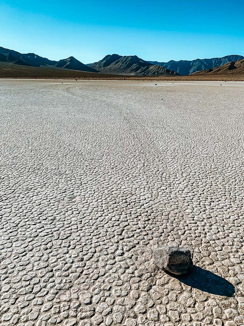
Striking arid scenery meets geologic wonder here in the Racetrack Playa. The playa (meaning dry lakebed) is best known for its moving rocks. Moving rocks? For real? More on that later….
The playa’s remote location and rugged location is not something you decide to experience on the fly. Getting there takes planning and preparation. First off, getting there from Furnace Creek Visitor Center takes about 3 hours given the terrain. The road to the racetrack is rough and bumpy and you will need a 4x4 or high clearance vehicle to get there. There is no cellphone coverage In this area and like most of Death Valley, is unpatrolled, so if you get a flat tire, you either have to know how to change it or expect to be stuck here for a few hours.
About 10,000 years ago, climate changes caused the lake to evaporate which left behind at least 1,000 ft thick beige colored mud. As soon as you step out onto the playa, you will be greeted by these “sailing stones”. And yes, they do move. Check out the tracks…

Although multiple researchers have tried for more than 90 years to document a move taking place, it was mostly unsuccessful until December 21, 2013 when Interwoof’s Jim Norris and geologist cousin Dr. Richard Norris actually witnessed the event. From their observations, a combination of factors need to happen for the movement to happen. First, the playa fills with water deep enough to form into ice but shallow enough to expose the rocks. Next, the nighttime temperature needs to be freeze the water just enough to form sheets of “windowpane” ice (thin enough to move freely but thick enough to maintain strength). On sunny days, the ice melts and breaks up into large floating panels which light winds (10 miles per hour) drive across the playa pool. Then ice sheets then shove the rocks in front of them causing the movement and leaving trails in the soft mud below the pool surface. The rocks moved only a few inches per second, a speed that is almost imperceptible at a distance. Individual rocks would move for anywhere from a few seconds to as long as 16 minutes.
This is one of the few places in Death Valley where you can have some peace and quiet. Its isolated location probably deters a lot of tourists from coming to this area. Enjoy it while you can :)

12. EUREKA SAND DUNES
Location: South Eureka Rd., about 87 miles northwest of Furnace Creek Visitor Center
Distance: 3 miles long, 1 mile wide
Difficulty: Moderate
Allot: 1 -2 hours, depending on how little or how long you want to walk
Bathrooms: Vault toilet in parking lot.
Pet rating: Not friendly

The tallest (680 feet above valley floor) sand dunes in California, the Eureka Sand Dunes lie in the remote Eureka valley. The golden sand framed by the impressive limestone wall of the Last Chance Mountains is truly a sight to behold. Hike all the way up to the top of a dune (not easy!) and be rewarded with epic views. Not only that, if conditions are just right, you might just hear the sand “singing” - a mix of a rumbling and humming sound. The sound usually accompanies a slumping or avalanching movement of sand, triggered by wind passing over the dune or by someone walking near the crest. Some speculate that this phenomenon is caused by the friction of the sand grains sliding against each other while others believe that thin layers of gas trapped and released between the grains act as “percussive cushions’ capable of vibration, thus producing the sound.
Recreational activities such as sand boarding and off-roading are not permitted here in order to protect the endemic species of plants and animals found here.
These places are just the tip of the iceberg. There are more places to explore which I hope we can do someday again. I hope this post helps you plan an epic trip to Death Valley. Enjoy! Tell me what the best part of your trip is. Drop it in the comments below :)
